Christchurch Bay and Harbour Flood and Coastal Erosion Risk Management (FCERM) Strategy Engagement - Phase 2
The engagement has now closed. You can read a full report of the findings here.
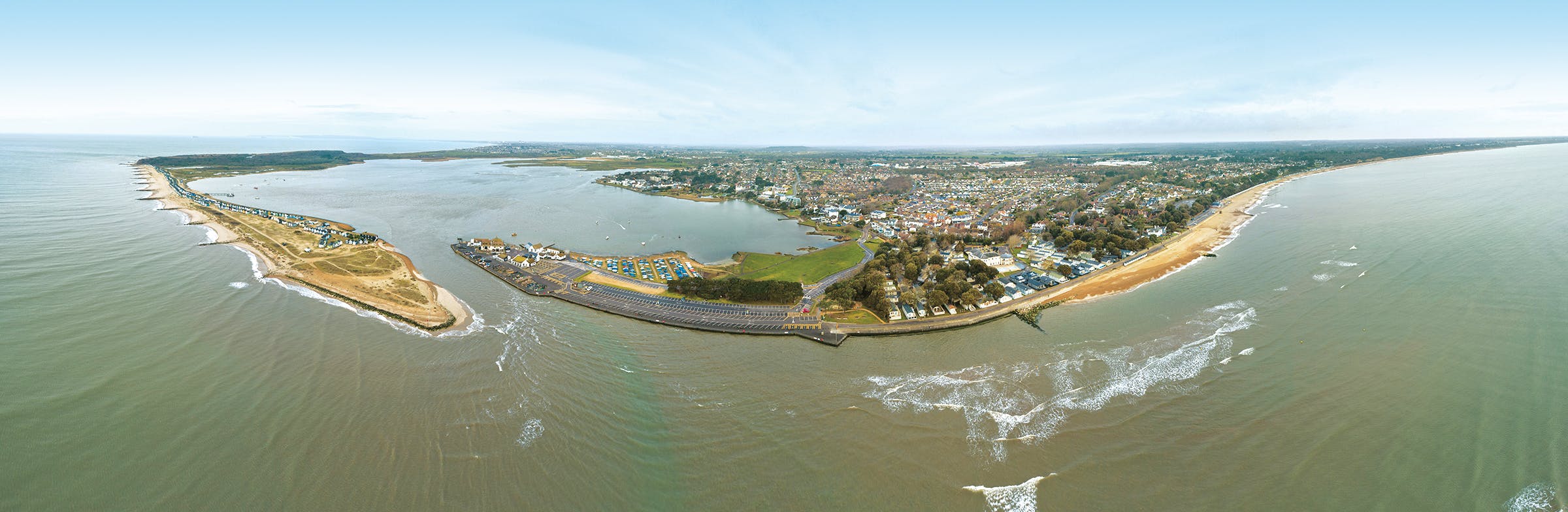
Bournemouth, Christchurch and Poole Council (BCP) and New Forest District Council (NFDC) are working together with the Environment Agency to produce a new coastal Strategy. It will guide how the frontage from Hengistbury Head to Hurst Spit, encompassing Christchurch Harbour, may be sustainably managed for the next 100 years.
We have developed a phased approach to deliver the Christchurch Bay and Harbour Flood and Coastal Erosion Risk Management Strategy (FCERM) by early 2024. It will identify where, when and broadly what type of works are needed to manage the risks of coastal flooding and erosion and what they may cost. It will also consider the effects of predicted climate change on coastal communities, including sea level rise and increased levels of storminess.
Phase 2 Engagement - 23 May to 26 June 2022
Following the Phase 1 engagement that ran in July - August 2021, we held a series of public engagement events that provided an opportunity for the public and key stakeholders to hear about our strategy progress. The second phase shared our initial findings from Phase 1and asked participants to tell us if we had missed something. We highlighted the scenario to explain: What happens if we don’t defend our coast? We presented a hypothetical situation where we abandon our existing defences and don’t prepare for climate change. This process was not designed to alarm but enabled us to evidence and justify what options there are to ‘do something’ to manage coastal flooding and erosion risk.
The second phase of public engagement events included two face-to-face drop-in sessions, one on-line event hosted by Dorset Coast Forum and an online survey. The events were held at the following times and locations:
- Monday 6 June 2022: Christchurch Library Octagon Space 10am-6pm.
- Thursday 9 June 2022: Milford on Sea Village Community Centre, 10am-4pm
- Tuesday 14 June 2022: public on-line event (hosted by Dorset Coast Forum) 7:00pm-8:15pm. Free tickets were available at Eventbrite
Have Your Say
- Survey: People could give us their views on Phase 2 by using our online survey which was open from 23 May until midnight on 26 June 2022.
- A PDF version of the online survey was available on this page which could be printed and return to us to the following address: Flood & Coastal Erosion Risk Management Team, BCP Council, PO Box 9548, Bournemouth; or dropped into the 'Have Your Say' box in any of BCP's libraries.
- Map: People could also drop pins and comment on the Strategy area using the map below if any additional points wanted to be made by location. However, respondents were encouraged to use the online survey as their main response to the engagement.
We presented summaries of our initial findings in the form of information boards, to help participants tell us if we had missed something or that we should consider before we start thinking about options to manage flood and coastal erosion risk. The boards could be found on the right hand side of this page and in the online survey.
Technical reports were also available on the right hand side of this page if respondents wanted to see the in-depth information we have gathered to provide the baseline information. Please note these reports are drafts as they will need to be updated following feedback during the engagement process if we have missed anything critical.
You can also read the results of our engagement in Phase 1 and council comments regarding feedback received about the 5 key geographical areas.
More information on Phase 1, Phase 3, Phase 4 and the full delivery of the Strategy can be viewed on the main engagement page here.
The Phase 2 engagement closed at midnight on 26 June 2022.
As the Strategy develops there will be further opportunities for people to get involved. All comments and opinions shared with us will be used to inform and develop the Strategy and it is anticipated that it will be adopted by early 2024. If you have any questions about the FCERM Strategy, please email coastal@bcpcouncil.gov.uk.
FCERM Strategy Area Map - Phase 2
In addition to your main response to the online survey, you can also make comments on the FCERM Strategy Area by dropping pins onto the map:
1. Click below to open the map
2. Once opened, you can zoom in and out, and drag to move around the screen
3. To see other users’ thoughts, simply click on pins that appear on the map
4. To add a pin click the + button on the left-hand side. Drag and drop a pin onto the map, where you can leave a comment or image.
5. Please note: everything you put on the map is accessible to others, so it is encouraged not to reveal any personal information.
Anything you decide to share with us will remain private and confidential in line with GDPR guidelines.
Thank you, we value your participation.
Documents
-
 FCERM Engagement Phase 2 Report (1.29 MB) (pdf)
-
 FCERM Phase 2 - Information Boards
-
FCERM Information Board 1 - New Coastal Strategy (588 KB) (pdf)
-
FCERM Information Board 2 - A Diverse Environment (1.35 MB) (pdf)
-
FCERM Information Board 3 - Existing Coastal Defences (188 KB) (pdf)
-
FCERM Information Board 4 - Coastal Flood Risk (234 KB) (pdf)
-
FCERM Information Board 5 - Coastal Erosion Risk (1.93 MB) (pdf)
-
FCERM Information Board 6 - Sediment Transport (1.56 MB) (pdf)
-
FCERM Information Board 7 - Have Your Say (163 KB) (pdf)
-
FCERM Information Board 8 - Next Steps (135 KB) (pdf)
-
-
FCERM Phase 2 Draft Technical Reports
-
Draft Baseline Economic Assessment 11-05-2022 (1.45 MB) (pdf)
-
Draft Christchurch FCERMS Coastal Processes Report 18-05-2022 (4.5 MB) (pdf)
-
Draft Christchurch FCERMS Environmental Baseline Report 17-12-2021 (4.13 MB) (pdf)
-
Draft Christchurch FCERMS Modelling Report 25-03-2022 (14.5 MB) (pdf)
-
Draft Defence Condition Assessment 18-05-2022 (6.44 MB) (pdf)
-

